Two Ceilings, Two Chambers
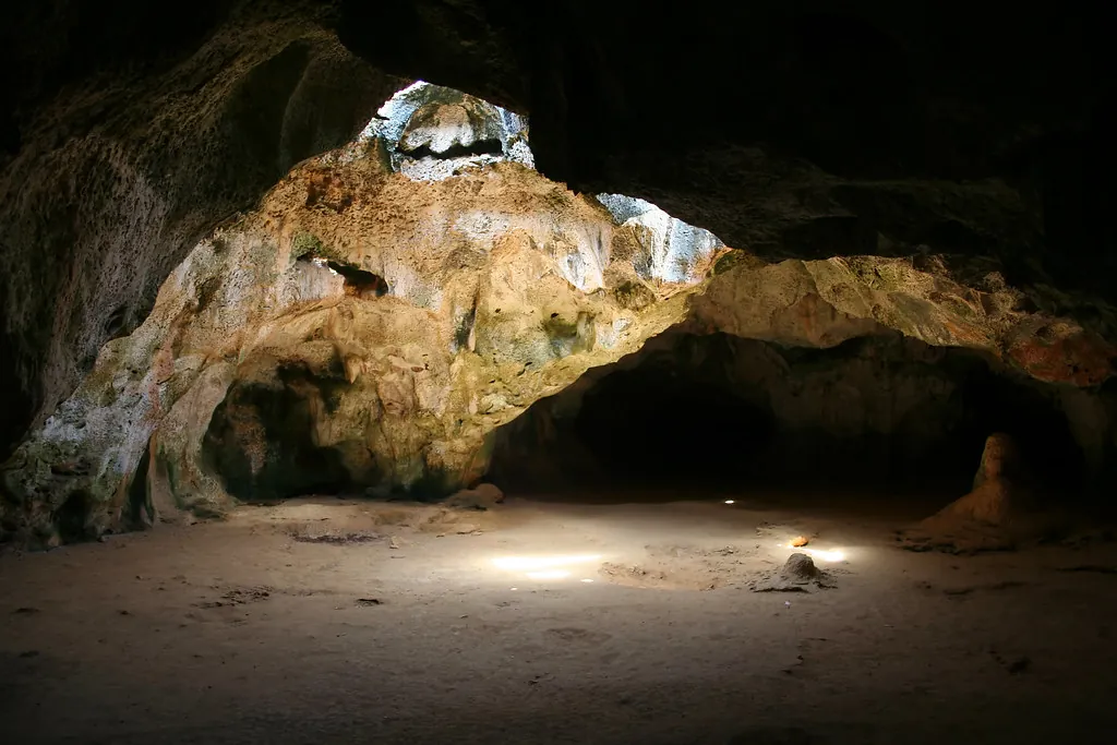
Ten steps past the entrance the temperature drops and the racket of the car park stops, as though somebody shut a heavy door behind you. Light comes through two holes in the ceiling in fat columns, lands on wet limestone, and makes dust visible that you would never notice otherwise. Nobody instructs you to whisper. Everybody does anyway.
Guadirikiri, which half the island spells Quadirikiri, is a limestone cave inside Arikok National Park with two chambers, a short corridor between them, and two collapsed sections of roof that now work as skylights. The walls are honeycombed with small solution pits; the air carries guano and wet mineral. It reads like a cathedral that ran out of money before the roof went on, which is not far from the geological truth. Those two openings are not windows somebody cut. They fell in.
Pack a torch even when the sunbeams are doing the heavy lifting overhead. The rear of the second chamber sees no daylight at all, and that is the bit the bats use.
Where Guadirikiri Sits in Arikok’s Landscape
The cave sits in the Santa Cruz district on the southern side of Arikok National Park, at roughly 12.4869 N, 69.9237 W, a short walk from the parking area up a slope of rough limestone rubble. The ground under your feet changes on the way in: dark diabase hills give way to pale fossil reef, and the vegetation thins from divi-divi scrub to cactus and watapana. Fontein Cave, the park’s other famous cavern, lies a few minutes further along the same road, and the Natural Pool at Conchi sits north of both, over the ridge. The San Fuego entrance and its visitor center are the park’s main orientation point, and the staff there answer geology questions with more patience than most people expect.
- Car park to cave entrance: a few hundred metres on uneven limestone, with a gentle climb
- Nearest sibling cave: Fontein, with its ranger station and rock art
- Nearest swimming water: the Natural Pool at Conchi, on the north coast, not inside any cave
- Landscape type: dry limestone karst, not rainforest, not jungle
The island gets roughly 400 to 500 mm of rain a year, which is the single most important number for understanding this cave. Dry country means slow water, and slow water means the dissolution that carved this place has been ticking along for a very long time. The Aruba National Park Foundation manages the ground the cave sits in, and the wider park circuit is mapped out on our Arikok National Park and nearby caves hub.
The Reef That Became a Rock
Aruba started as a volcano. The Cretaceous Aruba Lava Formation is the hard, dark basement left by ancient island-arc activity, and it is still visible in the diabase and tuff hills of the park’s north side. Later, the sea came back over the island more than once and left behind beds of coral, shells, and lime mud that hardened into the Seroe Domi Formation during the Miocene and Pliocene. That fossil-coral limestone is the host rock for Guadirikiri, and it is the reason the cave exists at all: basalt does not dissolve in weak acid, and limestone does. Every cave in Arikok grew in the limestone layer, because that is the only layer that can be eaten away by rain.
| Layer or Period | What It Is | Cave Relevance |
|---|---|---|
| Cretaceous Aruba Lava Formation | Volcanic basement from ancient island-arc activity | Hard, dark rock beneath the limestone; too tough to dissolve |
| Seroe Domi Formation, Miocene to Pliocene | Fossil-coral limestone laid down by marine transgressions | The soluble rock where Guadirikiri’s chambers grew |
| Quaternary karst phase | Rainwater dissolution and eventual roof collapse | Creates the two chambers and the skylight openings |
Limestone is the archive. Water is the editor. Guadirikiri is what happens when both work slowly enough.
The Government of Aruba and the national park foundation both treat the Seroe Domi limestone as part of the island’s natural heritage, which is a formal way of saying the rock under your feet is the reason you came.
Karst 101: How Acid Rain Hollows Out a Cave
Karst is the name for landscapes shaped by dissolving rock, and Guadirikiri is a textbook example sitting in a national park. The process needs three things: soluble limestone, water, and a route for the water to travel along. Aruba has all three in abundance, just slowly.
The Chemistry, Plainly
Rain picks up carbon dioxide from the air and from soil, which turns it into weak carbonic acid. That mildly acidic water seeps into cracks in the reef limestone, where it reacts with calcium carbonate and carries it away in solution. Nothing dramatic happens in a single storm. Give the same fracture a few hundred thousand wet seasons and the gap becomes a passage.
Why the Cave Follows Joints
A cave is not a random bubble in stone. Water takes the easiest route, which here means the joints and bedding planes already present in the fossil reef. It widens those lines, joins them up, and abandons the dead ends. Because the dominant fractures run vertically, the chambers end up taller than they are wide, and the bedding lines you can still see on the wall are the original seafloor layers.
- Solution flutes: vertical grooves on the wall where acid water ran down the rock
- Bedding lines: horizontal bands showing how the reef built up in layers
- Fossil coral: recognisable coral structures set in the limestone itself
- Rubble cones: collapsed ceiling debris on the floor, evidence the roof came down
The USGS karst explainer covers the same chemistry in more depth if you want the technical version. What matters inside Guadirikiri is that every groove and hollow you can see formed along a weakness the rock already had. Nobody has to touch the walls to speed that up, which is the reasoning behind the visitor rules for protecting cave formations.
Two Chambers and a Corridor
The layout is straightforward once you are inside: an entrance, a wide first chamber, a connecting passage that narrows and darkens, then a second chamber with its own hole in the ceiling and its own acoustics. Beyond the second chamber the passage closes off rather than continuing, so this is not a through-cave you can walk end to end. Distances below are approximate, taken from park materials and my own pacing with a slightly unreliable step count.
| Feature | Approximate Scale | Notes |
|---|---|---|
| Total passage length | 100 to 150 m | Entrance to rear wall, both chambers included |
| Chamber height | 15 to 20 m | Taller than wide because of vertical jointing |
| Roof openings | 2 to 4 m across | Collapsed skylights that admit the sunbeams |
| Floor | Uneven limestone rubble | Sturdy closed shoes help; stay on the marked route |
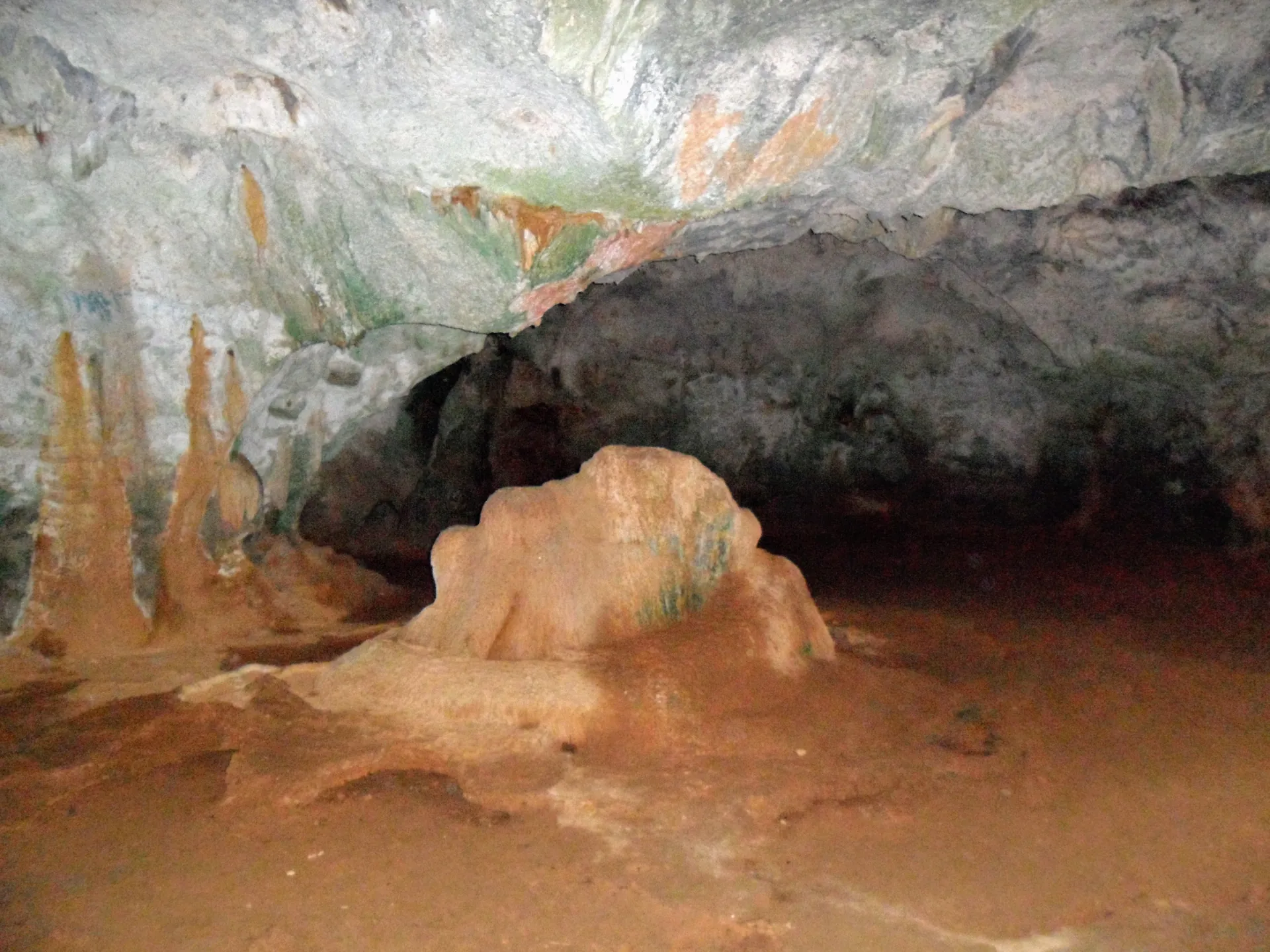
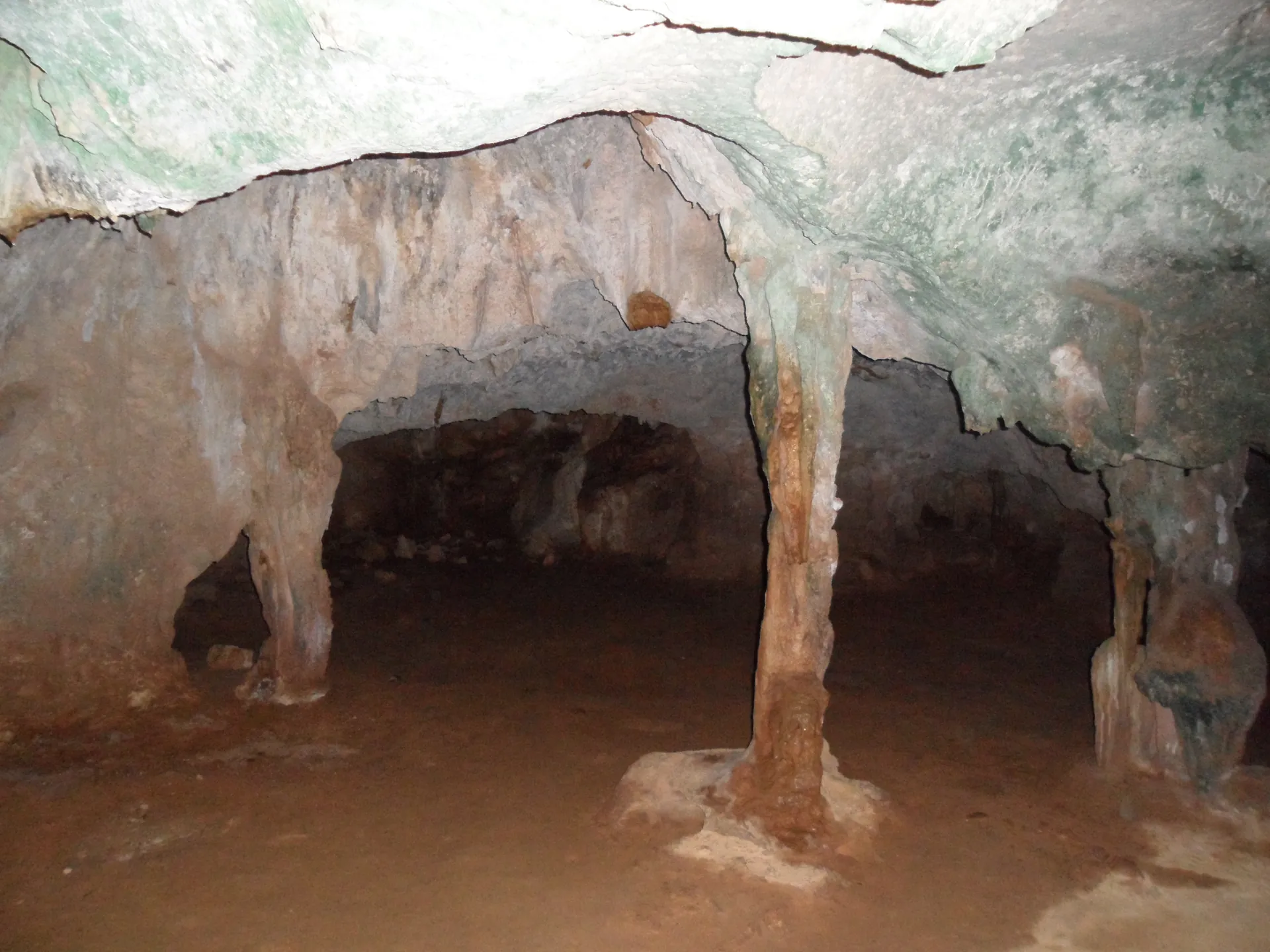
Chamber One
The first chamber greets you with a broad, dim space and the main roof opening above. The light shaft lands on damp limestone and shifts position through the morning, which is why photographers plan arrival times to the hour. Honeycombed pitting covers most of the surface. The chamber is generous in every direction except width.
Chamber Two
A short corridor connects you to the second chamber, which has its own collapsed roof hole and a quieter feel. Bats roost in the darker sections here. Keep your voice down, kill the flash, and let your eyes adjust for two or three minutes before you decide it is too dark to see anything.
The corridor between the chambers is the part people rush through. Slow down in there. The transition tells you how the water worked, and it took far longer than your schedule allows for.
The Roof Collapses, The Light Gets In
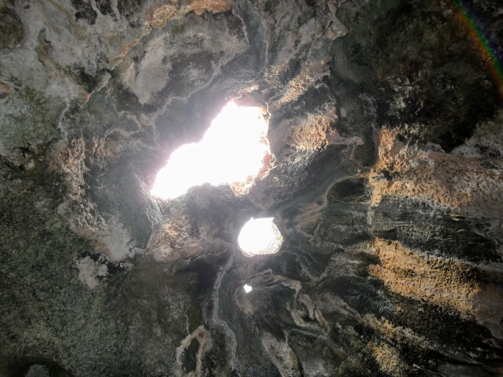
As dissolution widened the voids, the limestone above them lost the support it needed. Eventually sections of ceiling failed and dropped, leaving two ragged openings that now function as skylights. You can see the receipts on the floor: blocky rubble, some of it the size of a small car, sitting directly under each hole. This is not the same process as a surface sinkhole, which forms when the roof of a shallow void caves in and leaves a bowl in the ground. Guadirikiri’s openings sit above a tall chamber, so the light has a long way to fall before it hits anything.
Those two sun shafts are not windows. They are ceiling failures, graceful ones, thousands of years in the making.
The angle of those beams changes across the day and through the year, which has a real effect on what you can photograph. Our Guadirikiri Cave photos and chamber guide covers composition angles and low-light camera settings, and the timing guide explains when the shafts hit hardest.
Names, Spellings, and the People Who Knew the Cave
Spelling drifts on this island. Guadirikiri, Quadirikiri, Guadirikiri again, and older tourism leaflets that simply called it the Cave at Arikok. The national park standardised the written form in its own materials, while the Quadirikiri spelling still dominates a lot of English-language search traffic, which is why you will see both on the same road sign and the same website. Say it roughly as gwah-dee-ree-KEE-ree and nobody will correct you. The etymology claims pointing to a Caquetío or Arawakan root are plausible and repeated widely, but they are contested rather than settled, and no one has produced a translation that all the linguists agree on.
What the Record Supports
The cave is in Arikok National Park and has been under formal protection since the park was established. Its geology is verifiable: fossil-coral limestone, dissolution along joints, collapse skylights, and an ongoing bat colony. Park status shapes everything about access, noise, lighting, and where you are allowed to put your feet.
What Legend Adds
Caquetío and Arawak associations with Aruba’s caves belong to the island’s cultural memory and are worth knowing. Guadirikiri-specific claims are much harder to pin down. Fontein Cave is the Arikok cave with documented rock art. Here, treat the human story as regional context rather than a signed wall.
Spelling drifts and pronunciation argues with itself. The cave does not mind. The limestone is older than the paperwork.
The Caquetío, Fontein’s Drawings, and an Honest Comparison
The Caquetío were Arawakan-speaking people with clear cultural and trade links to the Venezuelan mainland, and they lived across Aruba long before European contact. Caves on the island gave them shelter, shade, fresh water, and places for ceremony. That much is well established for Aruba in general. What is far less certain is how specifically Guadirikiri featured in any of it. There are no confirmed pictographs here of the kind that draw visitors to Fontein Cave, where ranger-led access protects genuine rock art made with bat guano and plant pigment. When a tour operator advertises an “Indian Cave” in Arikok, they usually mean Fontein, not this one.
Some travel writing paper over that gap and imply Guadirikiri was a ceremonial site of major importance. I would rather tell you plainly: the archaeology here is thinner, and the honest comparison makes this the geology cave and Fontein the rock-art cave. The Aruba Tourism Authority lists both, and the wider park story sits on our Arikok National Park and nearby caves page.
Bats, Guano, and the Cave Food Web
Guadirikiri is not a dead rock tube with a nice light show. The southern long-nosed bat roosts in the darker recesses, and that species matters far beyond the cave walls: it pollinates the columnar cacti that give Arikok its silhouette, including kadushi and datu. A colony leaving at dusk is doing agricultural work across the whole island. Inside, the guano those bats drop feeds a small invertebrate community of beetles, mites, and fungi that recycle nutrients in permanent darkness, which in turn feeds the next layer up. Guano here is a slow geological deposit as much as it is a smell.
- Guano supports tiny invertebrates and fungi that recycle nutrients in the dark.
- Bats react to light, noise, and sudden movement far more than most visitors realise.
- Flash photography disturbs roosting bats; use a high ISO and a steady hand instead.
- Stay on marked paths and never handle wildlife or guano.
- Ranger guidance protects both the visitors and the colony, so follow it without negotiating.
The guano smell is not decay for its own sake. It is the cave’s pantry, and the bats are the delivery drivers.
The National Park Service cave etiquette guidance is a useful international benchmark for how to behave underground, and our own visitor rules and wildlife guidance applies it to Arikok specifically. If you take one thing away, make it this: no flash on bats, ever.
Protection Timeline: From Lava to National Park
| Time | Event | Why It Matters |
|---|---|---|
| Cretaceous | Aruba Lava Formation forms the volcanic basement | Creates the hard base beneath the later limestone |
| Miocene to Pliocene | Seroe Domi Formation limestone is deposited | Lays down the soluble rock that becomes karst |
| Quaternary | Dissolution, chamber growth, roof collapse | Produces the two chambers and the light holes |
| Caquetío period | Indigenous presence across Aruba | Regional cultural context for cave use on the island |
| 1997 to 2000 | Arikok National Park designated and opened | Brings Guadirikiri under formal protection |
| Present day | Ranger-guided access and conservation rules | Balances visitor interest with bat and geology protection |
Arikok covers roughly a fifth of Aruba, and that protection is the reason the cave floor is not covered in spray paint. Before park status, cave visits here were informal, unmonitored, and hard on the formations. Since then, access has been managed rather than closed, which is a decent outcome for a small island with a lot of visitors. The full park context, including how Guadirikiri pairs with Fontein, is on the Arikok overview, and the practical conduct rules live on the rules page.
Geology Myths and Evidence
Myth: It Is a Volcanic Bubble
Guadirikiri is not a lava tube. The island’s volcanic basement is older and far harder than the rock around it, and molten rock did not drain out of here. This cave grew in limestone by dissolution, one wet season at a time, along fractures that already existed.
Myth: The Arawak Drawings Are Here
Fontein Cave carries the well-known Arawak drawings in Arikok. Guadirikiri’s human history is regional and much less etched into the wall. If rock art is your priority, go to Fontein, ideally with a ranger, and enjoy this cave for its light instead.
Myth: There Is a Swimming Cave Pool
You cannot swim in Guadirikiri. The cave pool that older tours visited sits by the north coast, not inside these chambers, and swimming there was stopped for safety and conservation reasons. The experience here is light, rock, and bats, and park rules are clear about keeping it that way.
Two smaller misconceptions are worth clearing up while we are here. Aruba is not a jungle island, it is a dry karst and desert landscape, and there are no crocodiles or alligators living in these caves. The reptiles you will actually meet are whiptail lizards and the occasional green iguana warming itself on the limestone outside the entrance. If it is a geologist you are, the small stuff outside is worth as much time as the chambers inside.
Guided Context for the Geology-Curious
Rangers and licensed guides read this landscape differently from a self-guided walk, and some Arikok tour itineraries include Guadirikiri alongside Fontein and the north coast. A guide will point out the bedding lines, explain the collapse, and keep your group quiet around the roost, which is genuinely worth the money if you want the karst story told properly rather than pieced together from a signboard. Booking through a platform adds free cancellation and English-language support, while turning up and paying on site is cheaper and less flexible. I have done both, and the choice depends entirely on how much you care about a refund policy.
Keep Reading
- See the chambers and the light beams in the Guadirikiri Cave photo guide.
- Plan the wider cave circuit with the Arikok National Park hub.
- Learn the bat and formation rules on the visitor rules page.
- Time your visit for the sun shafts on the best time to visit guide.
- Work out the drive and park fee on the getting there page.